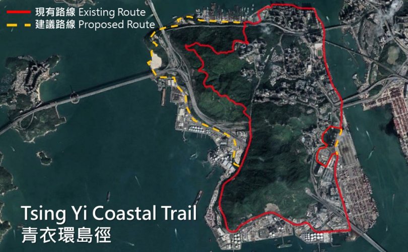
The Tsing Yi Coastal Trail
Since 2002, we have been advocating access along the waterfronts. After we introduced the “Hong Kong Island Coastal Trail” we received suggestions to create trails along other coastlines of Hong Kong. One such request was for a coastal route around Tsing Yi Island, connecting the Tsing Yi Promenade with the Tsing Yi Nature Trails and along Tsing Yi South.
Tsing Yi is the fifth largest island in Hong Kong with a population of around 200,000. The outer perimeter is around 16 km. It is an important transportation hub connecting New Territories West and the urban area of Hong Kong with cross-sea bridges.
Tsing Yi Island is characterized by three main areas: Residential, industrial, and nature. The proposed “Tsing Yi Coastal Trail” links all parts of Tsing Yi with a convenient coastal trail for residents and visitors.
We have studied routes, documented sights and destinations, and prepared proposals for improvements which can bring the route closer to the shore. To learn more about the trail, visit our website.
Route
Starting at the Maritime Square – Tsing Yi MTR station, walk south along the Tsing Yi Promenade with a view of Rambler Channel, and pass the Tsing Yi Swimming Pool to arrive at the Tsing Yi Public Pier. The pier once offered ferry services to Tsuen Wan and Central. Following the completion of rail and road links, the ferry service was suspended – but the pier remains as a gathering place, and an informal drop off and pick up point for different maritime operators.
Walking south under the Cheung Tsing Bridge and Tsing Yi South Bridge, Tsing Yi turns industrial. The route joins Tsing Yi Road via the elevator next to the Tsing Yi Preliminary Treatment Works. From there, walk down the path near Tsing Hung Road Playground and Tsing Yi Hong Wan Road along container terminals. Pass under Stonecutters’ Bridge and along the oil terminals at Tsing Sheung Road including Sinopec’s giant circular oil depot. Looking north, the mountains known as Sam Chi Heung act as a natural barrier between the residential areas and the heavy port industries along Tsing Yi Road. Continue west and after turning into Nam Wan, you find an abandoned Swire Paint Factory. Pass Sai Tso Wan and walk along the Nam Wan Tunnel and Cheung Tsing Tunnel for a view of other industries.
Next you join the Tsing Yi Nature Trail. At the top of the trail, you will have a panoramic view of Tsing Ma Bridge. This is a great spot for sunset and night scenes. Turn into Fong Tin Mei Path near Cheung Wang Bus Terminal, from where you walk along Tam Kon Shan Road to Tsing Yi Northeast Park. Go through the park to return to the Tsing Yi Promenade. Passing the Tsing Tsuen Bridge, you arrive back at the starting point. You will have completed the 16km Tsing Yi Coastal Trail.
Creating a great adventure
The Tsing Yi Coastal Trail links together a marvelous variety of views, including cross-sea bridges, shipyards, container terminals, factories, parks and nature. We have put forward suggestions for improvements which will make Tsing Yi more enjoyable for both residents and visitors. These include fixing narrow footpaths, trails and out-of-date road signs. Included also is a suggestion for a new pedestrian walkway to link with the Lantau Link Visitors Centre. This would make it easier to enjoy a great stopover, and enhance visitation.
We need your support lobbying the government on the improvements of the Tsing Yi Coastal Trail. Tell us your comment here.
Click here to learn more about Tsing Yi Coastal Trail!


青衣環島徑
自2002年,創建香港一直提倡讓市民能接近岸邊。去年我們曾簡介「港島環島徑」的路線,其後收到許多公眾意見,建議我們將構思拓展到港島以外的地方。當中我們收到不少街坊的意見希望嘗試在青衣環島遊。
青衣是香港第五大島,人口超過20萬。青衣島面積雖然不大,但卻是本港重要的交通樞紐,島上有多條跨海大橋將市區及新界西和大嶼山連接起來。
在短短數小時的步行,大家可看見青衣住宅、工業及大自然三種截然不同的景貌。透過「青衣環島徑」的計劃,我們期望能接通青衣的海岸線,為遊人提供一個方便、可行的沿海行人道。
因此,我們著手研究路線,進行了多次的實地考察,沿途紀錄了不同的景點,並找出多個需要改善的地方,希望盡可能將市民帶近到青衣岸邊。想了解更多青衣環島徑的資訊?歡迎參閱我們的網頁。
路線
從青衣城出發,沿著青衣海濱長廊南行,可欣賞藍巴勒海峽的景色,一直前行,經過青衣游泳池便到達青衣碼頭。昔日的碼頭曾提供客輪服務來往荃灣及中環,隨著島上的跨海大橋落成,島上陸路交通改善,航線已停航多年,但碼頭仍是不少人出海的上落點。
繼續向南面走,經過長青橋及青衣南橋底,便即踏入青衣的工業地帶。經污水處理廠旁的電梯回到青衣路,再緩緩走下青鴻路遊樂場旁的小徑,前往青衣航運路。穿過昂船洲大橋橋底,走到青尚路的盡頭,更可一睹青衣路旁一個個巨型圓桶油庫。而身後三度高低起伏的山脈,正是分隔工業帶及住宅區的天然屏障「三支香」。轉入南環的路段時,更有一座廢棄的工廠,它就是太古漆廠的舊址。其後到達西草灣一帶,沿青衣西路緩緩上斜,從南灣隧道和長青隧道的出口上經過,回頭就可從高眺西草灣一帶的重工業區。
再向前行便會到達青衣自然徑的入口。在自然徑登頂後,即可將青馬大橋景色盡收眼簾,於黃昏時更可欣賞大橋日落夜景。在長宏邨巴士總站旁轉入芳田美徑,於担杆山路直行,便到達青衣東北公園。穿過公園重回青衣的海濱,一路沿岸邊走便回到青衣海濱長廊,途經青荃橋橋底,便回到我們的起點,完成16公里的青衣環島徑。
開心暢遊青衣環島徑
青衣環島徑沿途包括大橋、工廠、公園及自然徑等景色,但我們實地考察後發現沿途仍有多個問題,例如行人路狹窄、未有更新路牌等。因此我們提出了七項改善建議,希望能夠令遊人更享受在青衣探索的過程。
除此以外,我們更希望將環島徑的走路線向西擴展,接駁現行西面的小路,並連接到青嶼幹線觀景台,為環島徑增添更多景點和可能性!
因此,我們需要你的支持去游說政府改善現有的不足,按這裡告訴我們你對環島徑的意見!
更多有關青衣環島徑的資訊,請歡迎參閱我們的網頁。