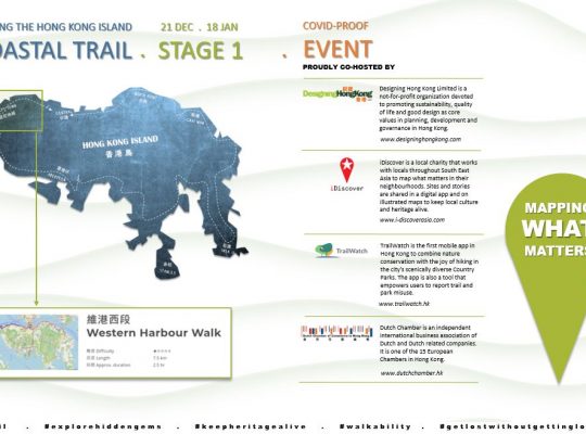
Hong Kong is famous for its well-developed network of mountain trails. With most people living near the coast in Hong Kong, Designing Hong Kong has embarked on a quest to connect coastal trails – see https://www.coastaltrail.hk/.
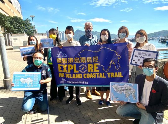
Government has adopted our proposal for the Hong Kong Island Coastal Trail and is now working on resolving the missing links. We have also recommended alignments for the Tsing Yi Coastal Trail and the Tuen Mun – Tseung Kwan O Coastal Trail.
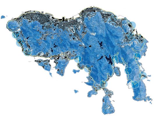
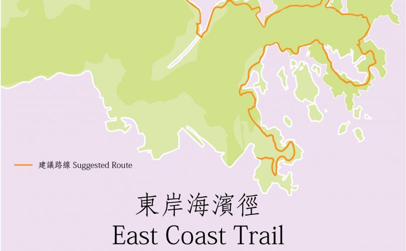
Today we release our proposal for the alignment of the East Coast Trail – a route from Tai Po to Tseung Kwan O. Covering a distance of 90 kilometres, this trail meanders as much as possible along the waterfronts and crosses over mountains where necessary.
Proposing the alignment of the East Coast Trail
The proposed trail is divided into 12 sections, offering a delightful journey from Tai Po Market Railway Station along the Tolo Harbour coastline, passing notable landmarks and scenic spots. You’ll traverse the Ma On Shan Promenade, explore the Sai Kung with its rich biodiversity, and embark on a hiking adventure through picturesque landscapes. The trail includes beautiful beaches, camping spots, and the opportunity to appreciate nature’s wonders, including flowing streams and distant mountain views. The trail concludes at Lohas Park, Tseung Kwan O, providing a fulfilling and memorable 90-kilometre experience.
The East Coast Trail is the fourth coastal trail to be proposed by Designing Hong Kong in collaboration with TrailWatch. The goal of our coastal trail development program is to promote connections along waterfront throughout Hong Kong as there are generally close to residential areas. Moreover, our picturesque waterfronts offer enjoyable experiences, stunning views and a cooler climate, for individuals of all age groups and physical abilities. For more information about our projects, please visit https://www.coastaltrail.hk/ect.html.
The 90km East Coast Trail is divided over 12 sections
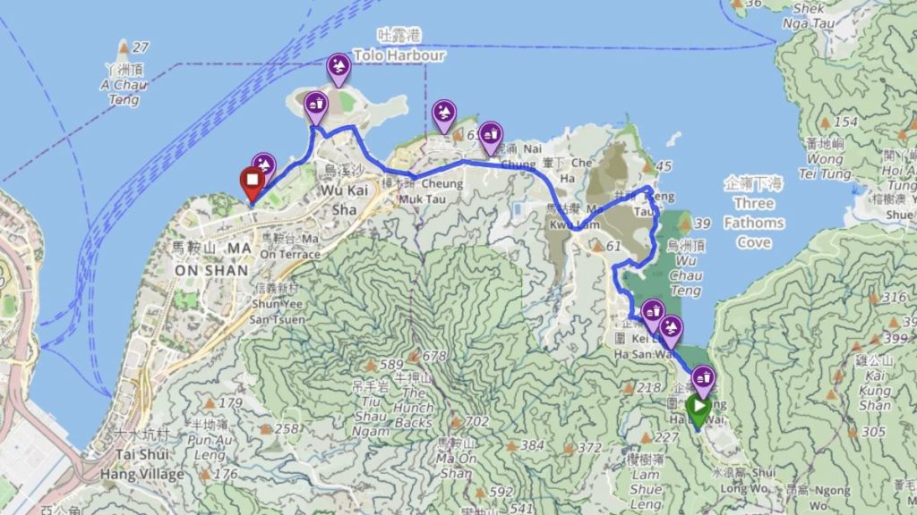
1. Pak Shek Kok Section (Length: 6.5km / Highest point: 10m)
Pak Shek Kok Section is well developed and flat. It passes through Tai Po Market, Hong Kong Science Park, and The Chinese University of Hong Kong. The route offers stunning views of Tolo Harbour, with famous attractions and waterfront parks for tourists to explore and appreciate the beauty of the New Territories.
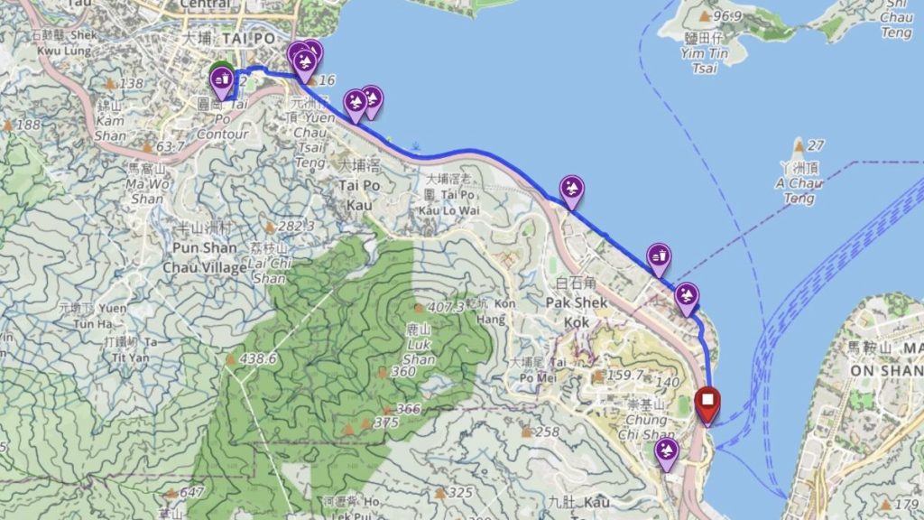
2. Ma On Shan Section (Length: 6.5km / Highest point: 10m)
The Ma On Shan section is approximately 6.5 kilometres long, running flat along the opposite coast of Tolo Harbour. It passes through Tai Shui Hang and Heng On before reaching Ma On Shan. The route is well developed and includes a cycling path and the Ma On Shan Park which are popular with local residents.
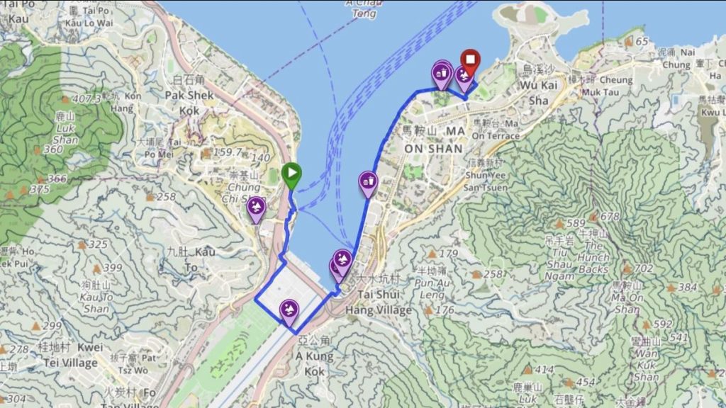
3. Nai Chung Section (Length: 7.5km / Highest point: 30m)
The Nai Chung Section connects Kai Ling Ha and Wu Kai Sha, spanning a total length of 7.5 kilometres. The route follows Sai Sha Road and detours through two of Hong Kong’s ecologically valuable sites of scientific interest (SSSI). Hikers can enjoy beautiful sea views and the scenic mountains of western Sai Kung.
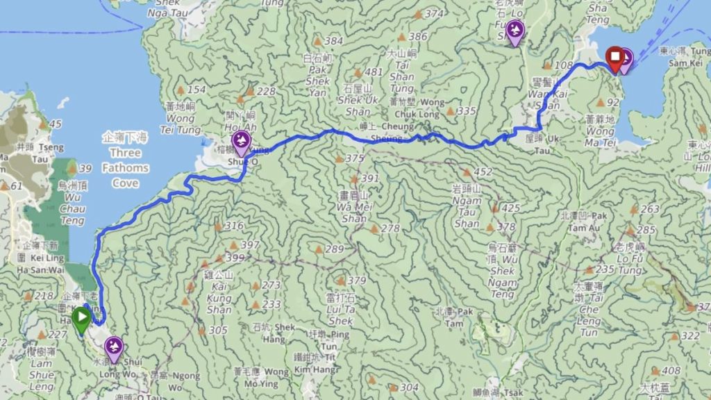
4. Cheung Sheung Section (Length: 9.5km / Highest point: 320m)
The Cheung Sheung section spans a total length of 9.5 kilometres and passes through scenic spots such as Shui Long Wo and Yung Shue O. It follows the hillside hiking trails and eventually reaches Wong Shek Pier. Visitors can enjoy the beautiful sea views of Kei Ling Ha and hike the mountainous area of the Sai Kung Country Park, including Cheung Sheung (320m).
5. Ham Tin Wan Section (Length: 10km / Highest point: 160m)
The Ham Tin Wan Section starts at Wong Shek Pier and intersects with the Wong Shek Family Walk, then passes through To Kwa Peng, Ham Tin Wan, Chek Keng, and finally concludes at Sai Wan Pavilion. Along this section, hikers can enjoy the continuous mountain ranges and pristine sandy beaches. The heights vary from sea level to a maximum of 160m.
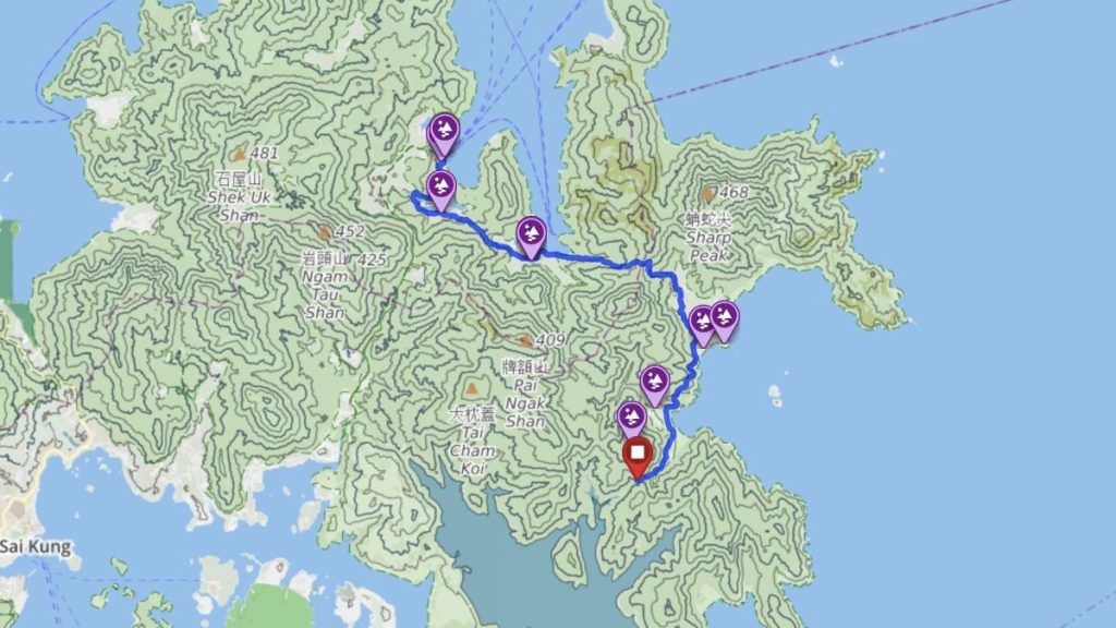
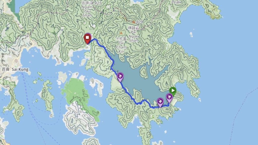
6. Long Ke Section (Length: 5.5km / Highest point: 315m)
The Long Ke Section starts at Sai Wan Pavilion and follows the MacLehose Trail Section 2 through Long Ke, and ultimately concludes at the East Dam of the High Island Reservoir. Along this section, hikers can enjoy the scenic views of the mountain ranges and pristine sandy beaches. The endpoint at the East Dam of the High Island Reservoir is within the Hong Kong UNESCO Global Geopark, offering unique geological features for visitors to appreciate. The height difference of the walk varies from the beautiful Long Ke Beach at sea level to the nearby Sai Wan Shan at 315m.
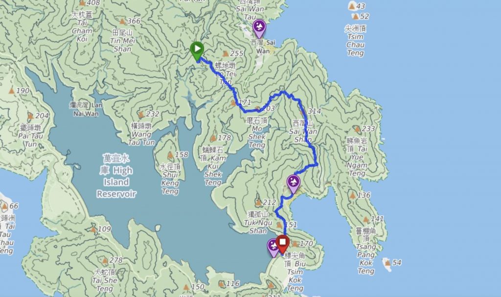
7. High Island Reservoir Section (Length: 9.5km / Highest point: 135m)
The High Island Reservoir Section spans a total length of 9.85 kilometres and takes visitors around the High Island Reservoir before reaching Pak Tam Chung, the main entrance of the Sai Kung Country Park. Along this section, hikers can enjoy the natural landscapes within the Hong Kong UNESCO Global Geopark and witness the grandeur of Hong Kong’s largest reservoir.
8. Sai Kung North Section (Length: 7.5km / Highest point: 40m)
From Pak Tam Chung the trail runs along the coastline with scenic views of Tsam Chuk Wan, Sam Nga Hau, and the Inner Port Shelter. Following this road will lead you to the centre of Sai Kung town.
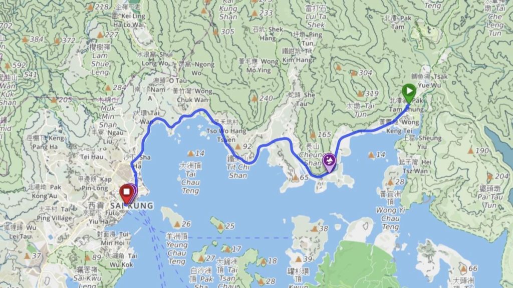
9. Sai Kung South Section (Length: 9km / Highest point: 140m)
Welcome to the scenic walking route from Sai Kung town centre to the Hong Kong University of Science and Technology (HKUST). This route allows you to appreciate the rural areas of Sai Kung, as well as stunning sea views and hidden natural gems at Nam Wai and Campers’ Beach.
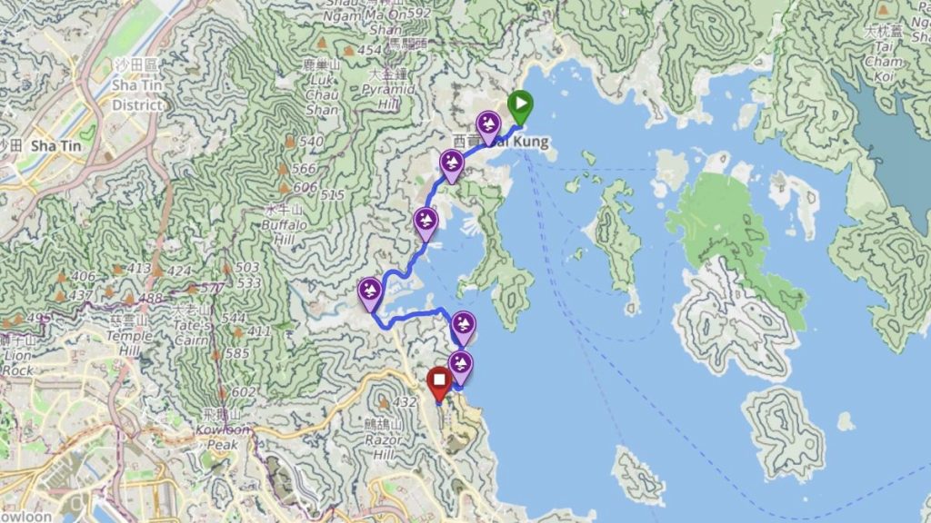
10. Silverstrand Bay Section (Length: 6.5km / Highest point: 160m)
Visitors hiking along the Silverstrand Beach Section from the Hong Kong University of Science and Technology pass through Silverstrand Bay and ultimately reach Tai Au Mun. Walking along this stretch of road provides a scenic view of the beautiful coastline of Silverstrand Bay.
11. Tai Au Mun Section (Length: 6km / Highest point: 290m)
This route starts at Tai Au Mun and follows the Lobster Bay Country Trail, ascends Ping Tok Hang Shan (215m) and Tai Ling Tung (290m). The route offers scenic coastal views of Lobster Bay. The circular route brings you back to Tai Au Mun. The Lobster Bay Country Trail has a total length of approximately 6 kilometres and offers ideal locations for kite flying.
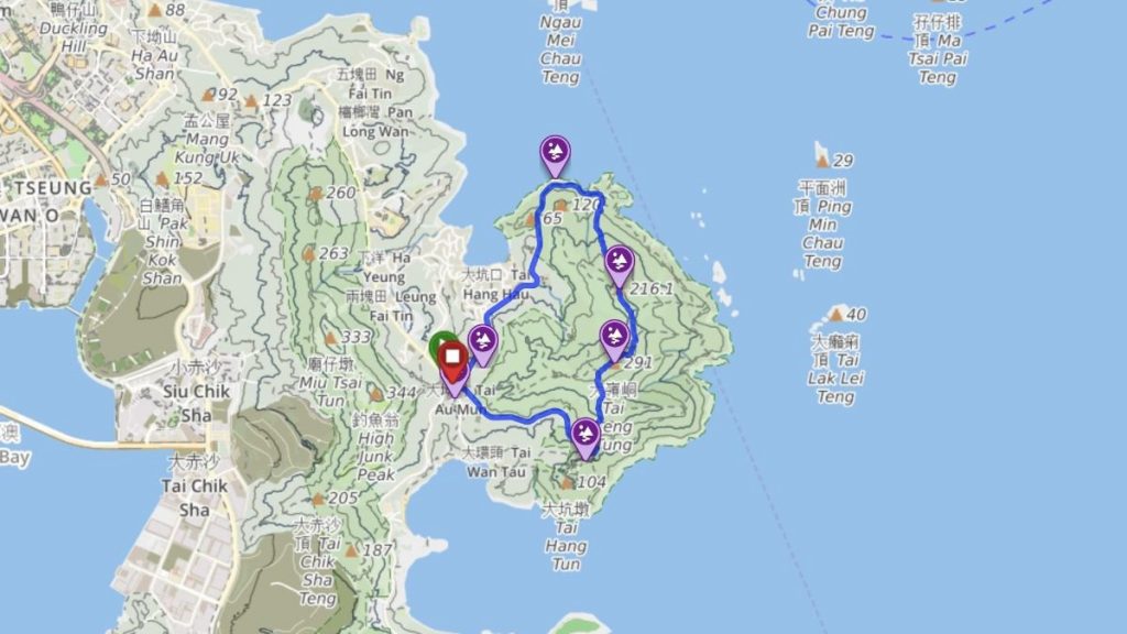
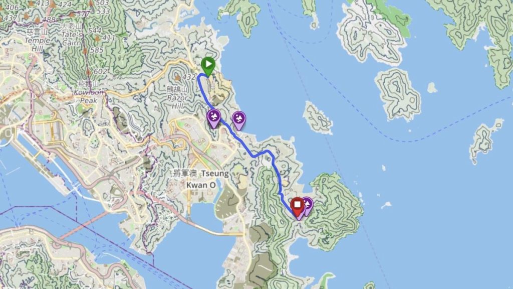
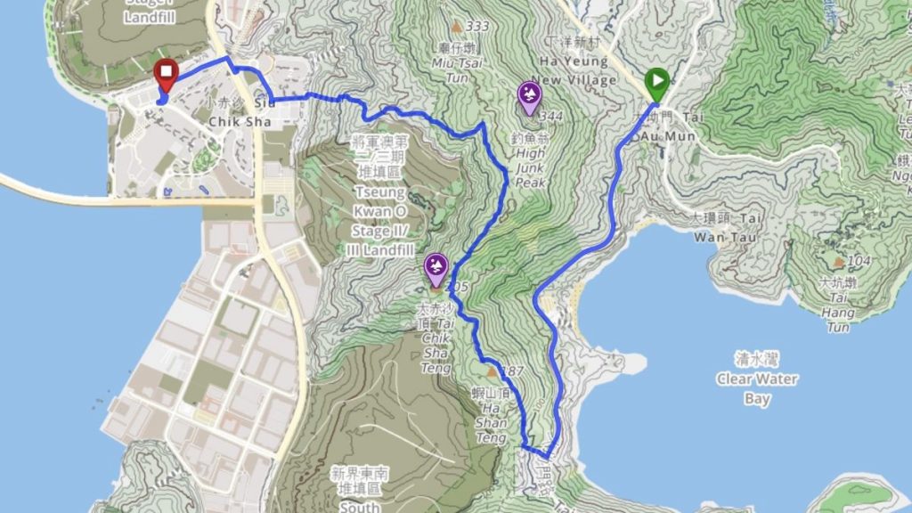
12. High Junk Peak Section (Length: 6km / Highest point: 240m)
The High Junk Peak section starts from Tai Au Mun, follows Tai Au Mun Road to Ha Shan Tuk, then ascends to the summit of Tai Chik Sha. From there, you can decide to detour via High Junk Peak. Finally, you return to the urban area and the MTR station at LOHAS Park, the end point of the Coastal Trail from Tai Po to Tseung Kwan O.
The East Coast Trail – An Unforgettable Adventure
The East Coast Trail is a pathway along the eastern side of Hong Kong, stretching from Tai Po to the Tseung Kwan O waterfront. This route runs along Tolo Harbour, through the Sai Kung Country Parks and Sai Kung town, through Clear Water Bay and ends at Logan’s Park. The route offers visitors both sea and mountain views. In the future, as more waterfront promenades open up connecting more areas in Hong Kong, more people of different abilities can enjoy the pleasure hiking Hong Kong’s coast lines.
Please refer to our website for more information about the East Coast Trail.
If you have any feedback or would like us to research more waterfront promenades, please feel free to email us at [email protected]. Your input will help us improve Hong Kong’s waterfronts experiences for the public.
東岸海濱徑
香港擁有發達的行山徑網絡。但香港大多數居民都居住於沿海地方,因此創建香港開始著手研究建立連貫的海濱網路,詳情可參閱https://www.coastaltrail.hk/。
政府採納了我們港島環島徑的建議,並正在努力將港島的海濱連接。我們早前亦發布了青衣環島徑和屯門至將軍澳海濱徑的推薦路線。
今天,我們發布東岸海濱徑的建議路線。路線由大埔伸延到將軍澳全長90公里,蜿蜒沿岸而行,盡可能帶你探索香港東岸的海岸線。
東岸海濱徑的建議路線
建議路線共分為12個段,從大埔墟站起步,沿著吐露港海岸線展開一段愉快的旅程。經過馬鞍山海濱長廊後,就會踏入充滿生物多樣性的西貢區,展開一場被大自然所包圍的冒險,沿途欣賞如畫的風景。路線會經過海灘、露營地點,各樣大自然奇觀包括溪流和山景等都可以在西貢找到。路線的終點位於將軍澳的康城,一次充實而難忘的90公里旅程以此作結。
東岸海濱徑是由創建香港及TrailWatch合作提出的第四條海濱徑。我們希望透過這個倡議促進和建立香港各個海濱地區之間的聯繫。海濱徑適合各年齡層和體能水平的人士探索,路徑將提供愉快的體驗和迷人的景色。欲了解更多有關東岸海濱徑的資訊,請到訪https://www.coastaltrail.hk/ect.html。
90公里的東岸海濱徑分為12段:
1. 白石角段(長度:6.5公里 / 最高點:10米)
白石角段路線發展完善且平坦。路線由大埔墟起步、經過香港科學園到達香港中文大學。這條路線提供了令人驚嘆的吐露港景色,遊客可以探索著名景點和海濱公園,欣賞新界的美景。
2. 馬鞍山段(長度:6.5公里 / 最高點:10米)
馬鞍山段全長約6.5公里,沿著吐露港對岸的平坦路線延伸。途經大水坑和恆安,最終抵達馬鞍山。這段路線發展完善,包括自行車徑和馬鞍山公園,是當地居民常用的設施。
3. 泥涌段(長度:7.5公里 / 最高點:30米)
泥涌段連接企嶺下和烏溪沙,全長7.5公里。路線沿著西沙路,經過兩個香港生態價值高的具特殊科學價值地點 (SSSI)。沿途亦可以欣賞到美麗的海景和西貢西部的山景。
4. 嶂上段(長度:9.5公里 / 最高點:320米)
嶂上段全長9.5公里,途經水浪窩和榕樹澳等風景名勝。它沿著山腰的遠足徑前行,最終抵達黃石碼頭。遊客可以欣賞到企嶺下的美麗海景,並在西貢郊野公園的山脈間遊走,包括受歡迎的郊遊地點嶂上(海拔320米)。
5. 鹹田灣段(長度:10公里 / 最高點:160米)
鹹田灣段起點位於黃石碼頭,與黃石家樂徑交匯,然後經過土瓜坪、鹹田灣、赤徑,最後結束於西灣亭。這路線可以欣賞到連續的山脈和原始的沙灘。海拔高度從海平面起伏,最高點達到160米。
6. 浪茄段(長度:5.5公里 / 最高點:315米)
浪茄段起點位於西灣亭,沿著麥理浩徑第二段經過浪茄,最終結束於萬宜水庫東壩。這路段可以欣賞到山脈和沙灘的風景。萬宜水庫東壩位於香港聯合國教科文組織世界地質公園內,提供了獨特的地質特徵供遊客欣賞。路徑的高度差異從海平面到西灣山的海拔315米。
7. 萬宜水庫段(長度:9.5公里 / 最高點:135米)
萬宜水庫段全長9.5公里,帶領遊客繞過萬宜水庫,最終抵達西貢郊野公園的主要入口—北潭涌。這路線可以欣賞香港聯合國教科文組織世界地質公園中的自然景觀,並目睹香港最大水庫的壯麗景象。
8. 西貢北段(長度:7.5公里 / 最高點:40米)
從北潭涌出發,這路線沿著海岸線延伸,將會經過斬竹灣、三丫口和西貢海的美景。沿著路徑前行,將會抵達西貢市中心。
9. 西貢南段(長度:9公里 / 最高點:140米)
從西貢市中心出發一直沿海岸到達香港科技大學。這條路線讓你欣賞到西貢的鄉村地區,還有南圍和露營灣等地的壯麗海景和自然景色。
10. 銀線灣段(長度:6.5公里 / 最高點:160米)
從香港科技大學出發,經過銀線灣,最終抵達大坳門。沿著這段路線步行,可以欣賞到銀線灣美麗海岸線的風景。
11. 大坳門段(長度:6公里 / 最高點:290米)
這條路線起點位於大坳門,沿著龍蝦灣郊遊徑前行,攀登平托坑山(海拔215米)和大嶺峒(海拔290米)。路線提供了龍蝦灣沿岸的風景,包括聞名的綠蛋島。該路線的終點亦設於大坳門。龍蝦灣郊遊徑全長約6公里,是郊遊的理想路線。
12. 釣魚翁段(長度:6公里 / 最高點:240米)
釣魚翁段起點位於大坳門,沿著大坳門路前行至蝦山篤,然後攀登至釣魚翁的登山口。從那裡可以決定繞道經過釣魚翁。再沿山徑返回城市區域,並抵達康城港鐵站,這也是東岸海濱徑的終點。
東岸海濱徑 — 一段難忘的冒險
東岸海濱徑是位於香港東部的一條沿海路徑,從大埔延伸至將軍澳海濱。這條路線穿越西貢地區,為遊客提供了大自然的美景。未來隨著更多海濱長廊的開放,連接香港更多地區,不同能力的人士將能夠享受香港海岸線上步行的樂趣。
請參考我們的網站以獲取有關東岸海濱徑的更多資訊。
如果您有任何反饋或希望我們研究更多海濱長廊,歡迎透過[email protected]聯絡我們。您的意見將有助於我們改善香港的海濱體驗。