Please tell us your comments here! 快啲入黎做我們的網上問卷調查啦!
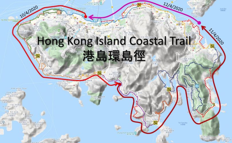
We have surveyed a 65-kilometre hiking route as close as possible to the shores of Hong Kong Island. The plan for creating a “Hong Kong Island Coastal Trail” has been cooking for a while. Since 2002 we have advocated access along the waterfront of Victoria Harbour and works are proceeding. In 2010 we started to focus on linking Kennedy Town to Stanley, a route which was recently sign posted as the “Southern District Coastal Trail”. Last year we explored the links from Stanley to Chai Wan and onwards to Shau Kei Wan. During the survey we documented the sights and destinations, and identified improvements which can be made to bring the route closer to the shore.
Route
Leave from the Hong Kong Observation Wheel in Central and walk along the busy ferry piers via Shun Tak Centre along the shore to the Instagram Pier, the western cargo working area in Kennedy Town. Walk up along Victoria Road and down onto Sandy Bay rocky beach. Explore the dead end waterfront promenade along the HKU sports pitches before backtracking to the road to arrive at Cyberport Waterfront Park. From there walk up Cyberport Road and over Waterfall Bay down along the 1,000 statues at Wah Fu’s waterfront. After industrial Tin Wan wonder through the Aberdeen fish market and follow the promenade along Aberdeen’s colourful harbour. Use the pedestrian footbridge over the Heung Yip Road nullah to connect to Wong Chuk Hang Station and Ocean Park. From there find Mills & Chung Path to the beaches of Deep Water Bay and Repulse Bay. Opposite South Bay Road number 18 walk up the trail over to Stanley. After Stanley find the Stanley East Catch Water by going up the stairs at the Stanley Mound Fresh Water Pumping Station to walk to Tai Tam. Go down along the bottom of the Tai Tam dam and up Hong Kong Trail Section 7 to the long set of stairs from To Tei Wan up to Shek O Road and the start of the Dragon’s Back trail. Here are three choices: Go up Dragon’s Back, take a bus to Shek O, or walk to Cape D’Aguilar Road and boulder down the rock stream onto Shek O beach. From Big Wave Bay there is a well-trodden route over Cape Collinson to Siu Sai Wan promenade. After the industrial waterfront of Chai Wan you reach Heng Fa Chuen’s tree lined waterfront. For now, walk up Shing Tai Road and find the informal trail along the south of the highway to get to Shau Kei Wan. From there the Quarry Bay Park and promenade take you to North Point. Make your way onwards to the Causeway Bay typhoon shelter and the Wanchai waterfront where waterfront works are in progress. From the Convention Centre you can get back to the ferris wheel to complete the 65km Hong Kong Island Coastal Trail.
To learn more about our survey, click here. Please let us know if you have any comments as well!
從2002年起,創建香港一直提倡讓市民可以接近維港的岸邊。在2010年,我們開始研究由堅尼地城步行到赤柱的可能性,當中一部份已經成為了現時的「南區海濱長廊」。在2019年,我們開始探索赤柱步行到柴灣的可能性,並進一步延伸到筲箕灣。我們沿途紀錄了不同的景點,並找出了多個需要改善的地方,盡可能將人帶近到岸邊。這條65公里長的「港島環島徑」就逐漸成形。
路線
從中環犘天輪出發,經過中環碼頭和信德中心就到達西區公眾貨物裝卸區,亦即是聞名的「Instagram Pier」。向西面走,經過堅尼地城到達域多利道,再緩緩走下大口環的小石灘。跟著香港大學運動中心旁的海堤一直走,便要回到碼路並到達數碼港海濱長廊。經過數碼港道就會找到了瀑布灣,然過穿過華富海傍的千尊神像,再路過田灣的工廠,眼前就是香港仔漁市場和避風塘。沿著香葉路一直走到黃竹坑和海洋公園,從這裡可以找到苗鍾徑並一路沿岸邊走到深水灣咎淺水灣,穿過南灣道 18 號對面行山徑就可以到達赤柱。經過赤柱後,在赤柱崗抽水站的梯級拾級而上就到達赤柱東引水道,繼續走便會到達大潭。往下走到大潭堤壩的壩底,再接駁到港島徑第七段,就會到達土地灣。在土地灣可以選擇走上龍脊,乘巴士到石澳,或者走到鶴咀再沿石澗前往石澳泳灘。走到大浪灣,沿歌連臣角到小西灣海濱,經過柴灣工業區、杏花邨的樹蔭海濱,再經盛達路公路右旁的非官方路徑就能到達筲箕灣。筲箕灣海濱一直連接到鰂魚涌,並延伸到北角。繼續走到銅鑼灣避風塘,穿過灣仔和會展海濱,再走不久,就回到我們的起點 — 中環摩天輪。
更詳盡的紀錄,可以到這裡查看。如果你有任何意見亦歡迎話比我們知 !